Finding reliable weather forecasts for remote outdoor locations is crucial for safe and enjoyable adventures. Whether you’re hiking in the mountains, camping in the wilderness, or exploring a remote region, knowing the weather conditions is essential. This article dives deep into how to find accurate and trustworthy weather forecasts for remote areas, discussing the different methods and strategies to stay informed and prepared.
Understanding the Challenges of Remote Forecasting
Difficulties in Data Collection and Model Accuracy
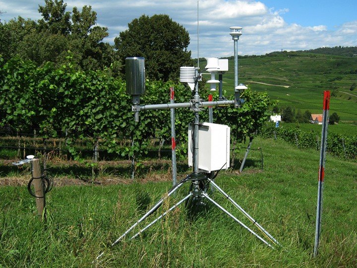
Reliable weather forecasting, especially for remote outdoor locations, often presents challenges due to limited data collection infrastructure. In areas with sparse population and fewer weather stations, the data available to forecasting models is inherently less comprehensive. This leads to a lower level of accuracy in predicting specific weather patterns in remote regions. Models may struggle to account for unique microclimates and terrain-specific effects, making predictions less precise for mountainous or hilly areas compared to flatter regions. Factors such as elevation changes, proximity to water bodies, and local weather phenomena can all significantly influence conditions. For instance, a forecast for a valley might be dramatically different from a forecast for a nearby mountain summit.
The Importance of Diverse Sources
This limited data often necessitates using a diverse range of sources to get a more complete picture of potential weather conditions. Relying solely on one model or source can be inadequate. Outdoor enthusiasts need to employ a strategy that blends insights from multiple sources—from commercial weather services to citizen science projects and local weather reports. Combining these insights can significantly increase the reliability of forecasts, potentially mitigating some of the limitations inherent in models developed for densely populated areas.
Evaluating Commercial Weather Services
Limitations of Generalized Models
Commercial weather services often provide detailed forecasts, but these are frequently optimized for densely populated areas. Generalized models may not accurately capture the unique weather patterns found in rugged terrain, mountainous regions, or remote areas. The spatial resolution of the models might be insufficient to predict localized changes in weather, leading to less accurate forecasts for specific locations. Understanding the models’ limitations is crucial for applying the predictions to your actual location.
Combining with Local Expertise
Complementing commercial services with insights from local communities can significantly improve the accuracy of your weather predictions. Seeking input from experienced hikers, campers, or residents of the area you’re planning to visit can provide crucial localized details. These individuals may have intimate knowledge of the specific microclimates and weather patterns in the region, which may be missed by generalized models.
Utilizing Citizen Science Initiatives
The Power of Community Input
Many citizen science projects focus on gathering weather data in remote areas. These initiatives can help fill critical gaps in data collection, providing more accurate forecasts. For instance, through citizen-recorded observations of precipitation, temperature, and wind conditions, these projects collect valuable data that can be integrated into predictive models. These observations can supplement the data from commercial weather services, potentially improving the forecast accuracy for your specific location.
Exploring Online Communities and Forums
Online forums and social media groups dedicated to remote outdoor activities often serve as invaluable resources for finding current and past weather conditions. Experienced outdoor enthusiasts often share real-time observations and predictions based on their knowledge of the specific terrain. Accessing such communities can provide up-to-date insights about changing weather patterns and potential microclimate variations.
Leveraging Advanced Technology
Smartphone Applications for Weather Tracking
Numerous smartphone applications offer valuable insights into potential weather conditions for outdoor activities. These apps can leverage local weather stations or incorporate data from multiple sources. Some applications also consider the user’s location and altitude to provide more personalized predictions. Checking these apps against other sources can be beneficial for evaluating the credibility of the information and getting a more comprehensive picture of the conditions.
Using GPS Tracking for Accurate Location
Using a GPS-enabled device can help ensure the accuracy of the location-specific forecast you’re receiving. Providing the precise coordinates of your planned route to the application, or the relevant weather services, is critical to getting an accurate forecast for your location and route.
Staying Updated on Weather Changes
Real-time Updates for Accurate Predictions
In remote areas, weather conditions can change rapidly. Regularly checking updates on the latest weather information is critical. Utilizing services that provide frequent updates or alerts related to changing weather patterns is essential to prepare for potential surprises or risks.
Monitoring for Localized Phenomena
In remote regions, specific weather phenomena, like thunderstorms or sudden wind gusts, can occur without widespread notice. Continuously monitoring and updating on local weather forecasts, especially in mountainous regions or near bodies of water, is vital. Combining forecast data with real-time observations from local sources or social media groups can help to anticipate potential challenges.
Importance of Data Interpretation
Understanding Model Limitations
Understanding the limitations of weather models is crucial. Models may oversimplify complex atmospheric patterns in remote areas, and results must be interpreted with awareness. Be prepared for unforeseen changes and always have a backup plan.
Evaluating Forecast Accuracy Based on Previous Observations
Analyzing historical data for the specific location is useful. Look at past weather patterns and weather events to refine predictions and understand how accurate forecasts have been in the past. This can provide a better perspective on the reliability of the forecast.
Safety Precautions in Remote Locations
Preparing for Changing Conditions
Always plan for potential changes in weather. Having backup gear, such as extra layers of clothing, rain gear, and warm clothing, is critical in case forecasts change rapidly. Check for potential delays due to adverse weather and be flexible with your itinerary.
Contacting Authorities and Sharing Plans
Communicate your travel plans to someone and share the predicted weather conditions. Check with local authorities about any advisories or potential closures and keep them informed of your progress.
Utilizing Multiple Sources for Enhanced Accuracy
Combining Forecast Information
By combining data from multiple sources—commercial services, local input, and citizen science—you can significantly improve the accuracy and reliability of weather forecasts in remote locations. This creates a more robust understanding of the current and anticipated conditions.
Using Local Experience for Fine-tuning Forecasts
Always check forecasts with local knowledge. Talking to experienced individuals in the area about their insights and expectations can help refine the forecasts for specific conditions, potentially increasing your ability to anticipate surprises or risks. Consult local weather stations or experts whenever possible.
Technology Advancements and Data Collection
Innovations in Forecasting Technology
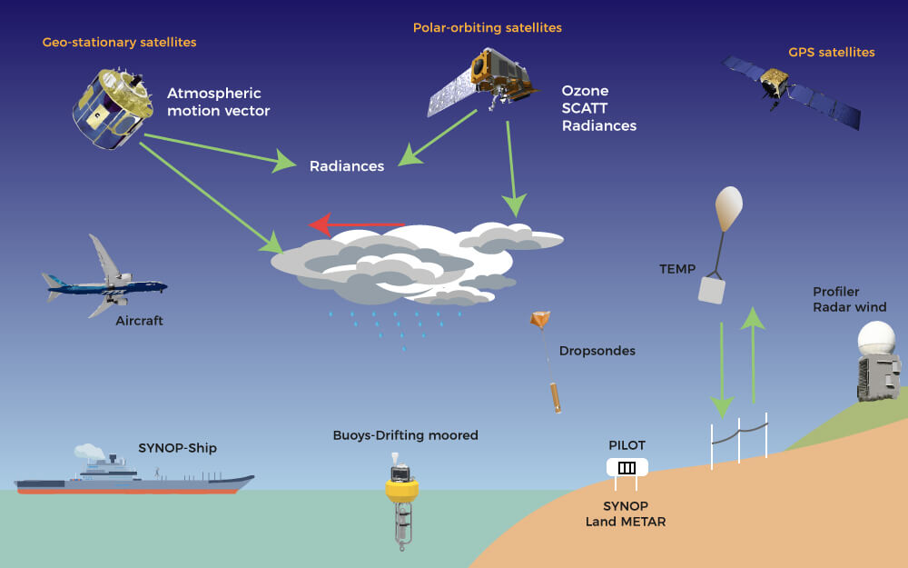
Advances in technology, particularly in satellite imagery and numerical modeling, are constantly improving weather forecasting models. Satellites gather data from vast areas and provide critical information for building more accurate predictions. With increased data availability and improved modeling techniques, predictions for remote regions may become more reliable.
Future of Real-time Data Collection
Continuous monitoring systems in remote areas, through the use of drones, sensors, or other technologies, can enhance data collection. This will generate more precise and current data for better predictions, especially for rapidly changing weather patterns.
FAQ:
How can I find accurate weather forecasts for remote areas when commercial services aren’t available?
Accessing accurate weather data in remote locations often requires combining multiple sources. Look for local weather stations or citizen science projects that collect data in the area you’re visiting. Social media groups and forums dedicated to remote areas can be invaluable, as locals often share their weather observations and insights. Additionally, exploring weather apps designed for specific regions or remote areas can sometimes provide more localized forecasts. It’s crucial to critically assess any information found.
What are the key differences between weather forecasting models used for densely populated versus remote areas?
Weather models for densely populated areas typically employ more intricate datasets and sophisticated algorithms, leveraging extensive data collected from numerous sensors and weather stations. In remote regions, models might rely on fewer data points or less dense networks, potentially leading to lower accuracy in finer details of weather patterns. However, with advancements in technology, models are continually improving, and data collection in remote areas is expanding. Satellite imagery and advanced numerical models are helping bridge this gap.
How do I interpret weather forecasts for rugged terrain?
Understanding the unique microclimates in mountainous or hilly regions is paramount when interpreting forecasts. Mountain passes, valleys, and ridges often experience significantly varied weather conditions compared to surrounding areas. While the overall forecast might predict clear skies, local conditions could include sudden wind gusts, unexpected precipitation, or temperature inversions. Always check specific forecasts and, if possible, get input from locals for localized conditions.
In conclusion, finding reliable weather forecasts for remote outdoor locations requires a multifaceted approach. Understanding the limitations of various forecasting methods, utilizing diverse sources, and actively checking for updates are crucial for informed decision-making. By employing these strategies, outdoor enthusiasts can stay safe, make sound travel plans, and maximize their adventures. To find the most accurate and dependable forecasts, explore the resources provided in this article, and get ready for your next thrilling remote outdoor experience! Let us know in the comments below what outdoor adventures you are planning!